click image to view map
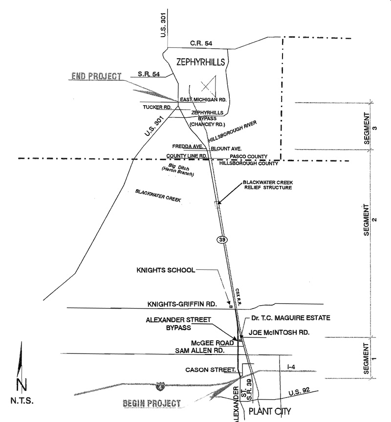
The Florida Department of Transportation (FDOT) conducted a Project Development and Environment (PD&E) Study to evaluate the expansion of S.R. 39 to a four-lane facility from the vicinity of Joe McIntosh Road in Hillsborough County to the vicinity of U.S. 301 in Pasco County, Florida. In addition, the FDOT is evaluating the extension of Alexander Street Bypass as a four-lane facility from 1-4 northward to S.R. 39 in the vicinity of Joe McIntosh Road.
Study Purpose and Need
S.R. 39 provides one of the few north-south routes within eastern Pasco and Hillsborough Counties. The proposed action’s purpose is to divert traffic from downtown Plant City and improve the capacity of the corridor. The need for the project was based on the evaluation of current substandard traffic operations within the study area, expected future quality of traffic flow along S.R. 39 based on the No-Build Alternative, and the projected future socioeconomic growth in the region of the project.
Proposed Improvements
Both the existing and design year conditions were evaluated, and various improvement alternative alignments were developed. A total of twenty (20) alternative alignments were developed in the area of the Alexander Street Bypass consisting of both urban and rural typical sections, two (2) alignments were developed from Knights-Griffin Road to Fredda Avenue, and five (5) alignments were developed from Fredda Avenue to U.S. 301.
After a thorough technical analysis and a comprehensive public involvement process, the study recommends the following improvements.
- From I-4 to Cason Street (Alexander Street Bypass): A four-lane divided facility, with 3.6 m (12ft) wide travel lanes, a 16.2 m (54ft) depressed median, 3.0 m (10 ft) outside shoulders with 1.5 m (5 ft) of the shoulder paved, 3.0 m (10ft) inside shoulders, and 21.9 m (73 ft) borders to accommodate a fill height of 1.8 m (6ft). The proposed design speed for this typical section is 110 kmlh (70 mph). This alignment will require 80.4 m (268 ft) of right-of-way. The recommended Build Alternative selected for this portion of roadway is Alignment R-H.
- From Cason Street to S.R. 39 (Alexander Street Bypass): A four-lane divided facility, with 3.6 m (12ft) wide travel lanes, a 16.2 m (54ft) depressed median, 3.0 m (10 ft) outside shoulders with 1.5 m (5 ft) of the shoulder paved, 3.0 m (10ft) inside shoulders, and 15.0 m (50ft) borders to accommodate a fill height of 0.9 m (3 ft). The proposed design speed for this typical section is 110 kmlh (70 mph). This alignment will require 66.6 m (222 ft) of right-of-way. The recommended Build Alternative selected for this portion of roadway is Alignment R-H.
- From S.R. 39 to Blount Avenue (Existing S.R. 39): A four-lane divided facility, with 3.6 m (12 ft) wide travel lanes, a 16.2 m (54 ft) depressed median, 3.0 m (10 ft) outside shoulders with 1.5 m (5 ft) of the Shoulder paved, 3.0 m (10 ft) inside shoulders, and a 13.8 m ( 46 ft) border on the west side of the roadway to accommodate a fill height of 0.45 m (1.5 ft) and an 8.4 m (28 ft) minimum border on the east side of the roadway. This alignment would share the ditch on the east side of the roadway with CSX Railroad. The proposed design speed for this typical section is 110 km/h (70 mph). This alignment will require 58.8 m (196 ft) of right-of-way. The recommended Build Alternative selected for this portion of roadway is Alignment B which acquires right-of-way from the west side of the roadway.
- From Blount Avenue to Shady Oaks Drive (Existing S.R. 39): A four-lane divided facility, with 3.6 m (12 ft) wide travel lanes, a 16.2 m (54 ft) depressed median, 3.0 m (10 ft) outside shoulders with 1.5 m (5 ft) of the shoulder paved, 3.0 m (10 ft) inside shoulders, and a 13.8 m (46 ft) border to accommodate a fill height of 0.45 m (1.5 ft). The proposed design speed for this typical section is 110 km/h (70 mph). This alignment will require 64.2 m (214 ft) of right-of-way. The recommended Build Alternative selected for this portion of roadway is Alignment D which acquires right-of-way from the east side of the roadway.
- From Shady Oaks Drive to U.S. 301: A four-lane divided facility, with 3.6 m (12 ft) wide travel lanes, 1.2 m (4 ft) bicycle lanes, a 16.2 m (54ft) depressed median, Type E curb and,gutter, and 1.5 m (5 ft) sidewalks. The proposed design speed for this typical section is 90 km/h (55 mph). This typical section will require 50.4 m (168ft) of right-of-way. The recommended Build Alternative selected for this portion of roadway is Alignment D which is a new connection with U.S. 301.
The proposed improvements will relocate 7 businesses, 1 non-profit (church), and 59 residences. These improvements will have a construction cost of $32.26 million, $6.45 million for engineering and inspection, $34.35 million for right -of-way acquisition, and $1.09 million for ponds (Alexander Street Bypass only) for a total of $74.15 million.
During the PD&E Study it was determined that a design variance would be required during the design phase of the project for the minimum border area from S.R. 39 to Blount Avenue. The standard border width per the Plans Preparation Manual is 12.0 m (40 ft). However, in order to minimize impacts to the community on the west side of the roadway due to the CSX Railroad along the east side of the roadway, the border area was reduced to 8.4 m (28 ft) and the open drainage ditch would be shared with CSX Railroad. In addition, after reviewing the alignment in the area of Knight-Griffin Road, the alignment and typical section were modified in order to avoid impacts to the Knights School.
Three historical properties are located within the project corridor: the Dr. T.C. Maguire Estate, the Knights School, and the Blackwater Creek Relief Structure. All three have been determined by the State Historic Preservation Officer (SHPO) to be eligible for listing in the National Register of Historic Places (NHRP). The Blackwater Creek Relief Structure is scheduled to be rehabilitated, along with the replacement of the Blackwater Creek Bridge, which will be advanced ahead of the rest of the S.R. 39 project corridor. The FHW A, in compliance with Section 106 of the National Historic Preservation Act and in consultation with the SHPO, has determined that the proposed action will have no effect upon the Dr. T.C. Maguire Estate and the Knights School. The FHWA has applied the Criteria of Adverse Effect found in 36 CFR Part 800.5 and has determined that the bridge replacement project will have an effect on the Blackwater Creek Relief Structure; however,based upon the conclusions noted in the previously submitted “Section 106 Consultation Technical Memorandum for the State Road 39 Blackwater Creek Bridges and Approaches” and the conditions outlined in a January 2000 letter of concurrence between the FHWA and the SHPO, the effect will not be adverse.