click image to view map
The Florida Department of Transportation (FDOT) conducted a Project Development and Environment (PD&E) Study Update to evaluate improvements to U.S. 301/S.R. 41 (Gall Boulevard) from S.R. 39 to south of County Road (C.R.) 54 in Pasco County, Florida. The objective of the update is to provide documented environmental and engineering analyses which would assist the FDOT and the Federal Highway Administration (FHWA) in reaching a decision on the type, conceptual design and location of the necessary improvements within the U.S. 301 PD&E study limits to accommodate future transportation needs in a safe and efficient manner.
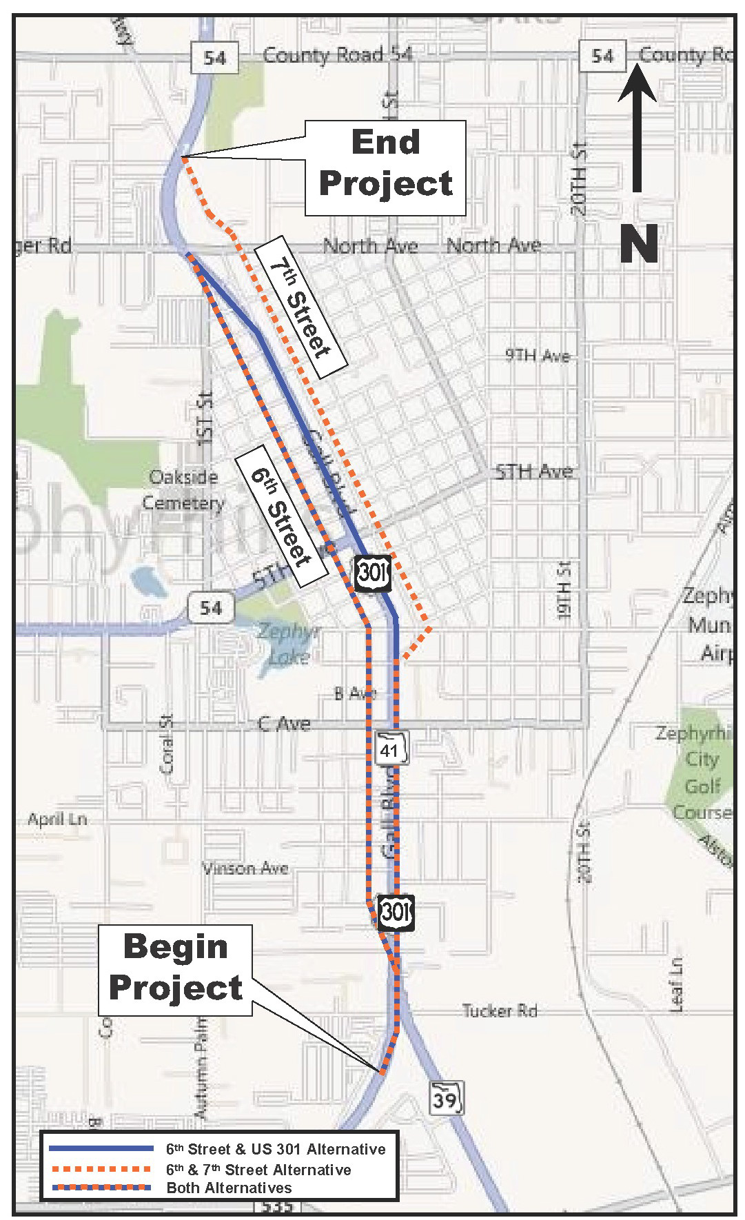
A Type 2 Categorical Exclusion (CE) and supporting Preliminary Engineering Report (PER) were completed in 2001 and are attached as Appendix F and G respectively. The Type 2 CE and PER recommended certain improvements which were submitted to the FHWA for review and acceptance. Location and Design Concept Acceptance (LDCA) was granted by FHWA on September 12, 2001 for that portion of the project from S.R. 39 north to A Avenue. Since the LDCA, ongoing coordination with the City of Zephyrhills resulted in the identification of an additional build alternative.
Study Purpose and Need
This report identifies the current and future deficiencies that should be expected along U.S. 301 if the existing geometric characteristics are maintained, and presents feasible improvement alternatives that will meet future traffic demands. This report documents the development of all improvement alternatives after consideration of socioeconomic, cultural and environmental effects. This Final draft presents the Recommended Alternative and the reasons for its selection.
Project Description
The PD&E Study Update identified the current and future traffic deficiencies that should be expected along U.S. 301 if the existing geometric characteristics are maintained and presents feasible improvement alternatives that will meet future traffic demands. After consideration of socioeconomic, cultural and environmental effects, feasible improvement alternatives were identified.
Project need was verified and refined in an updated Design Traffic Technical Memorandum (DTTM) prepared in December 2010. This analysis documents that existing year (2010) Annual Average Daily Traffic (AADT) volumes on U.S. 301 range from a low of 12,700 vehicles per day (vpd) north of South Avenue to a high of 20,900 vpd south of Fort King Road. A highway capacity analysis was conducted to evaluate existing levels of service along the U.S. 301 study corridor and the 6th and 7th Streets one-way pair. The results of the analysis indicate that in 2010, all 15 study intersections operated at an overall Level of Service (LOS) D or better during both the AM and PM peak hours. An analysis of arterial operations reveals that in 2010, two roadway segments did not operate at the adopted LOS standard D in either the AM or PM peak hours. The two roadway segments with a deficient LOS (LOS E) are listed as follows:
- Northbound 7th Street between Geiger Road and Fort King Road during the PM
peak hour; and - Southbound U.S. 301 between 12th Avenue and S.R. 54 (5th Ave.) during the AM
peak hour.
Crash records were examined for the most recent five-year period (2005-2009) to assess a level of motor vehicle safety along the U.S. 301 study corridor. A total of 500 crashes occurred during this five-year time frame, which resulted in 493 injuries and three fatalities. The U.S. 301 segment from Geiger Road to south of C.R. 54 is the only roadway segment with a five-year average safety ratio greater than 1.0.
Design year (2035) traffic projections were developed for the U.S. 301 study corridor using the Tampa Bay Regional Planning Model (TBRPM), Version 7.0. Design year AADT volumes on U.S. 301 are projected to range from a low of 28,400 vpd north of South Avenue to a high of 49,000 vpd north of S.R. 39. If no improvements are made to U.S. 301 and the 6th and 7th Streets one-way pair, 13 of the 15 study intersections are projected to operate at an unacceptable LOS (LOS E or worse) during the AM and/or the PM peak hours. Similarly, unless improvements are made, failing LOS is projected on the U.S. 301 arterial roadway segments.