click image to view map
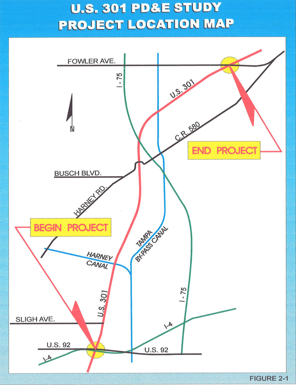
The FDOT conducted a Project Development and Environment (PD&E) study for the improvement of U.S. 301 (S.R. 41) generally between I-4 (S.R. 400) and Fowler Avenue, in Hillsborough County, Florida.
The objective of the PD&E study was to provide documented information and analyses which would help the FDOT and the FHW A reach a decision on the type, design and location of the necessary improvements along U.S. 301 to accommodate the future traffic demand in a safe and efficient manner. The PD&E study satisfied the requirements of the National Environmental Policy Act (NEPA) and the FHWA in order to qualify the design, ROW acquisition, and construction phases of the project for future federal funding.
This report documented the information necessary to confirm the need for this project and developed and evaluated various improvement alternatives as they relate to the transportation facility. Information relating to the engineering and environmental characteristics essential for alignment criteria were set and alternatives were developed. Comparison of alternatives was based on a variety of parameters using a matrix format. This analytical process identified the alternative that would have the least impact while providing the necessary improvements. The design year of the analysis was Year 2020.
Study Purpose and Need
This report identified the current and future deficiencies that should be expected along U.S. 301 if the existing geometric characteristics are maintained, and presents feasible improvement alternatives that will meet future traffic demands. This report documented the development of all improvement alternatives after consideration of socioeconomic, cultural and environmental impacts, identifies the most viable alternative, and presents the reasons for rejecting other alternatives.
Deficiencies
U.S. 301 between I-4 and Fowler Avenue is a 2-lane roadway which has operated since its construction without any major improvements. The section south of this project is a 4-lane divided roadway, which transitions to 2 lanes just north of l-4. Growth in this area has placed increasingly heavy traffic demands on this highway.
Traffic volumes for 1997 along U.S. 301 range from 10,000 vehicles per day (vpd) at Fowler Avenue to 27,500 vpd at I-4. The projected traffic volumes for the year 2020 range from 17,000 vpd at Fowler Avenue to 38,000 vpd at I-4. To accommodate the expected continued growth in traffic, this section of U.S. 301 will require four travel lanes, two in each direction. For a more detailed explanation of traffic volumes and analysis, see section 6 of this report, which summarizes the Traffic Technical Memorandum for this project.
Safety
The high traffic volumes in the section from I-4 to Sligh Avenue currently exceed the capacity of the two lane roadway, which increases the probability of crashes. Currently, there are approximately two crashes per million vehicle miles, which is above the statewide average of 0.7 crashes per million vehicle miles for similar two lane roadways. By the year 2020, the entire project length will be operating at a Level of Service (LOS) E or F, which is unacceptable. The existing two lane section of U.S. 301 from I-4 to Fowler Avenue has a number of characteristics which may be contributing to the accident rate. The two lane roadway is undivided, which makes the chance of a head-on collision due to an errant vehicle more likely than on a divided roadway with a median to separate opposing traffic. The use of the opposing traffic lane to pass slow moving vehicles also increases the chance of a head-on collision. The lack of a median to control access for left turning vehicles increases the number of conflicts with through traffic as vehicles enter and leave driveways along the roadway. At the signalized intersections, particularly Harney Road, the high turning volumes result in an unacceptable amount of congestion to which a number of crashes may be attributed.
Consistency with Transportation Plan
The Hillsborough County Metropolitan Planning Organization (MPO) has the responsibility of developing a long range transportation plan for the county to serve the needs of the metropolitan area over the next 20 to 25 years. The adopted 2015 Long Range Transportation Plan (LRTP), updated in 1995 has identified the section of U.S. 301 from I-4 to Harney Road to be improved from two lanes to a four lane divided roadway.
This PD&E Study’s limits, from I-4 to Fowler Avenue, extend past the MPO’s terminus at Harney Road, for two reasons. One reason is that Fowler Avenue is a more logical terminus, having an interchange with I-75. The other reason is that the projected 2020 traffic volume will require four lanes for the entire project, including the section from Harney Road to Fowler Avenue, which is documented in the Traffic Memorandum.
The FHWA has approved the project limits, from I-4 to Fowler Avenue, with the understanding that Location and Design Concept Acceptance (LDCA) will only be granted for the section from I-4 to Harney Road in the MPO’s plan. A copy of the letter from the FHWA is included in Appendix B. The MPO has suggested in a letter (dated October 20, 1997) that if the FDOT plans on improving U.S. 301 between I-4 and Fowler Avenue, it request the MPO amend the LRTP to extend the northern limit of the U.S. 301 improvement’ to Fowler Avenue. The MPO will then consider including the section of U.S. 301 from Ramey Road to Fowler Avenue when the LRTP is updated in 1998 before the 2020 LRTP is finalized. If the MPO’s LRTP is amended so that the U.S. 301 project matches the PD&E Study limits prior to FHW A LDCA, then the entire section from I-4 to Fowler Avenue can proceed to final design when this study is complete. If the LRTP is amended after LDCA, then the remaining portion of the project can be reevaluated and subsequently approved by the FHWA.
Social/Economic Demands
According to population projections from Hillsborough County and the regional traffic model developed by FDOT’s Planning Department, travel demand is expected to continue to grow in this area. Most of the land on both sides of U.S. 301 is zoned as community mixed-use 12, which allows commercial, industrial, and residential uses, with a maximum of 12 dwelling units per acre. The future land use of this area is intended to be urban, with development allowed as transportation and public facility services needed to support these developments are made available. The section of U.S. 301 being studied is expected to become increasingly commercial (particularly the area near I-4) which will result in increased traffic on this road.
There are a number of industrial warehouse and distribution buildings under construction or planned in a five mile stretch of the U.S. 301 Conidor ending at I-4. These expansions total more than one million square feet of new buildings. One of these, Hampton Oaks, is within the project limits just
north ofl-4. The other industrial parks are on or near U.S. 301 between Bloomingdale Avenue and I-4.
Modal Interrelationships
There is no rail, mass transit, or HOY lanes planned for U.S. 301. Vandenberg Airport which is located near U.S. 301, serves small private aircraft and is currently expanding, adding a new runway to handle an anticipated increase in flights. This anticipated increase in volume at the airport will result in more vehicles on U.S. 301 and Maple Lane, contributing to the need for this project. Improvements at the signalized intersections, including Sligh Avenue/Maple lane, are to be incorporated in this project.
There are no existing sidewalks to serve pedestrian needs. Although pedestrian volumes are low at present, the number of pedestrians is expected to increase as the area becomes more urban and commercialized. Sidewalks are to be included in this project, along with a bicycle lane or paved shoulders for bicycle use.
Proposed Improvements
The preferred alternative (Alternative “D”) is a four lane divided suburban typical section consisting of two 3.6 m (12ft) travel lanes and 1.5 m (5 ft) outside paved shoulders in each direction. Drainage is handled by roadside swales on the outside of the travel lanes. Sidewalks are included between the right of way (ROW) line and the drainage swales.
This typical section can be built within the existing 61 m (200ft) ROW, except for intersection improvements at Sligh Avenue and Harney Road, stormwater ponds and floodplain compensation sites.
The preferred alternative includes bicycle and pedestrian facilities. Sidewalks will be built on each side of the roadway for pedestrian use. Pedestrian signals and crosswalks are to be constructed at the signalized intersections as part of this project. On the bridges, separate walkways for pedestrians will be built. For bicyclists, a five foot wide paved shoulder is available for their use. Street lighting is also recommended on this project, because of the high rate of crashes at night. Public transit can also be accommodated with the preferred alternative. Although there are no existing bus routes along this section of U.S. 301, the Hillsborough County MPO has emphasized the importance of allowing for expansion of Bus service to his area. As the area develops and the need for public transportation increases, future bus stop locations with bus pads and shelters can be added by constructing a side drain and filling in the ditch.
The Department anticipates continuing development and increasing traffic along this roadway, even beyond the design year for this project, 2020. Six lanes are likely to be required eventually, so the preferred alternative should and will accommodate this. When six lanes are required, it will be necessary (after FHW A approval of an environmental document) to convert the roadway to an urban section with a closed drainage system to avoid costly ROW acquisition. The preferred alternative shall be designed so that it can be conve1ted to an urban section with curb and gutter when widened to six lanes without reconstructing the pavement. A minimum gutter grade of 0.3% is to be used throughout the project to allow for the conversion to an urban section. This will require the use of a “sawtooth” profile at the beginning of the project which has a 3000 m (9800 ft) long section with a flat grade.