click image to view map
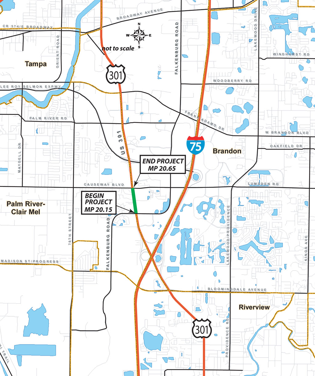
This Preliminary Engineering Report (PER) had been prepared for the Hillsborough County Engineering Services Department in cooperation with the Florida Department of Transportation (FDOT) as part of the Project Development and Environment (PD&E) Study for the widening of US Highway 301 (SR 43) from a 4-lane rural section to a 6-lane rural section. The project begins at Falkenburg Road and extends approximately 0.75 miles to the north to Causeway Boulevard.
The recommended typical section for the Build Alternative consists of six 12-foot travel lanes, three lanes in each direction, a 41-foot grass median, 12-foot outside shoulders (5 feet of which is paved) and 5-foot sidewalks will be added near the right-of-way (R/W) line from Falkenburg Road to Wes Kearney Way, thereby making the sidewalks continuous on both sides of the road for the length of the project. The existing 8-foot wide inside shoulders, 4 feet of which are paved, will be retained. The existing roadside swales will be re-graded for stormwater. The R/W width varies from 200 to 249 feet.
Two alternatives were considered, the Build Alternative and No-Build Alternative.
As a result of the Public Hearing, environmental studies and interagency coordination, the Build Alternative has been selected as the Recommended Alternative which will result in widening of US Highway 301 (SR 43) from a 4-lane rural section to a 6-lane rural section.
Study Purpose and Need
The purpose of this PER was to document the findings of the engineering evaluation for the improvements to US Highway 301 in Hillsborough County, Florida from Falkenburg Road to Causeway Boulevard as part of the PD&E Study. This report presented the engineering data and analysis needed to define the project improvements. The report also documented the existing physical features of the roadway and the existing environmental characteristics of the project corridor. The report defined the need for improvement, including the analysis of existing and projected traffic conditions establishing the requirements for the project improvements. The results of the analysis were summarized, and the analysis of the alternatives is documented. An alternative evaluation matrix, which compares the relative strengths and weaknesses of the No-Build Alternative and Build Alternatives developed for this study, is included in Section 8.0. This matrix helps identify the recommended alternative and perform a preliminary design analysis of the conceptual plans, including the evaluation of social, economic, and environmental impacts, as well as transportation needs. The conceptual design plans are included in Appendix A.
This report will serve as the document of record to move this project forward and to support decisions as the project advances through design and construction. This PD&E Study was conducted in accordance with FDOT guidelines and related federal, state, and local government requirements. Other supporting documents were prepared for this PD&E Study and include the following: Cultural Resource Assessment Survey (CRAS), SEIR, Environmental Technical Compendium, Pond Siting Report, Traffic Technical Memorandum (TTM), Air Quality Report and Noise Study Report.
Proposed Improvements
US Highway 301 is a principal arterial roadway that begins in Sarasota County, proceeds in a northeasterly direction, and exits the state of Florida northeast of the City of Jacksonville. Within the study area, US Highway 301 is a north-south 4-lane divided roadway within a wide R/W that varies from 200 feet to 249 feet (see Figure 2).
The Build Alternative increases the roadway from 4 lanes to 6 lanes by adding lanes to the outside of the existing lanes. The No-Build Alternative was also evaluated and was an alternative throughout the Public Hearing process.
The recommended typical section for the Build Alternative consists of six 12-foot travel lanes, three lanes in each direction, a 41-foot grass median, 12-foot outside shoulders (5 feet of which is paved) and 5-foot sidewalks will be added near the right-of-way (R/W) line from Falkenburg Road to Wes Kearney Way, thereby making the sidewalks continuous on both sides of the road for the length of the project. The existing 8-foot wide inside shoulders, 4 feet of which are paved, will be retained. The existing roadside swales will be re-graded for stormwater. The R/W width varies from 200 to 249 feet.