click image to view map
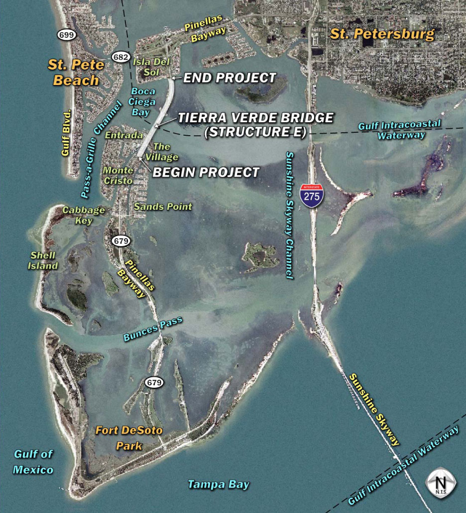
The PD&E Study limits encompass the portion of S.R. 679 from south of Madonna Boulevard (milepost 8.366) in Tierra Verde to south of S.R. 682 (milepost 9.454) in St. Petersburg, Florida, a distance of 1.088 miles (mi). The project is located within Sections 8, 17, and 20, Township 32 South, Range 16 East, and within the Pass-A-Grille Beach United States Geological Survey (USGS) quad map (quad Number 3022). Structure E is a low-level bascule structure that spans the Intracoastal Waterway, a marked federal navigational channel which generally runs between the mainland and the nearly contiguous barrier islands along the Gulf of Mexico. S.R. 679 is not part of the National Highway System (NHS), the Florida Intrastate Highway System (FIHS), or the Strategic Intermodal System (SIS); however, the Intracoastal Waterway within the PD&E Study area is on the SIS. In addition, both S.R. 682 and S.R. 679 are designated hurricane evacuation routes by the Florida State Emergency Response Team (SERT).
S.R. 679 was originally constructed in 1961 to join the man-made islands of Tierra Verde with Isla Del Sol in St. Petersburg in Pinellas County. S.R. 679 is a north-south urban minor arterial that provides the only vehicular access to the islands of Tierra Verde and Mullet Key, where Fort Desoto Park is located. S.R. 679 is part of the Pinellas Bayway toll system, which also includes S.R. 682.
Routine bridge inspections have identified safety and structural problems associated with the age of the existing bridge, including concrete delaminations, spalls, cracks, and other deficiencies. Structure E is functionally obsolete and is rated “scour critical.” It also contains fracture critical elements, meaning that members are subject to tension such that failure could result in collapse of the bridge. The remaining service life under normal maintenance conditions is estimated to be 6 years, meaning that under the current normal maintenance program, the bridge will need to be rehabilitated or replaced by year 2011.
Improvement alternatives considered for this facility include rehabilitation, rehabilitation (with widening), and replacement with a low-level bascule bridge, a mid-level bascule bridge, or a high-level fixed-bridge.
Study Purpose and Need
The purpose of the PD&E Study was to provide documented environmental and engineering analyses to assist FDOT and the United States Coast Guard (USCG), the lead federal agency, in reaching a decision as to the type, location, and conceptual design of roadway and bridge improvements to the S.R. 679 (Pinellas Bayway Structure E) crossing of the Intracoastal Waterway. The PD&E Study also satisfies the requirements of the National Environmental Policy Act (NEPA) and other state and federal regulations.
The PD&E Study documents the need for the improvements, and presents the procedures that FDOT utilized to develop and evaluate various improvement alternatives including rehabilitation and replacement of the existing double-leaf bascule bridge (Bridge Number 150049) known locally as the Tierra Verde Bridge. FDOT collected information relating to the engineering and environmental characteristics essential for alternatives and analytical decisions. FDOT then established design criteria and developed preliminary alternatives.
The comparison of alternatives is based on a variety of parameters utilizing a matrix format. This process identified the alternative which would have the least impact, while providing the necessary improvements. The study also solicited input from the community and users of the facility. The design year for the analysis is 2030.
Proposed Improvements
The proposed improvements will include replacing the existing two-lane double-leaf bascule bridge with a high-level fixed-bridge structure providing 65-ft vertical navigational clearance over the existing channel. The Village at Tierra Verde (The Village) driveway will be relocated to align with Madonna Boulevard (Option A), as shown in Appendix A. Based on the data provided by the bridge tender at Structure E and allowing for tidal fluctuations, this height would allow over 99 percent of the waterway users that currently use the channel to safely navigate under the proposed structure.
The proposed bridge replacement typical section includes one 12-ft lane and a 10-ft shoulder in each direction. The shoulders can accommodate bicyclists and disabled vehicles. A 5-ft sidewalk is included on the west side, separated from the shoulder by a concrete barrier wall. An 11-ft sidewalk is provided on the east side to accommodate Pinellas County’s planned multi-use path. The overall width of the fixed-span is 65 ft.
South of the bridge, the typical section transitions between a four-lane divided urban roadway with turn lanes and the undivided two-lane bridge. Lane, shoulder and sidewalk widths will be consistent with the proposed bridge. The proposed roadway typical section approaching the north end of the bridge is similar to the proposed bridge except it is elevated on embankment with a retaining wall on each side. The retaining wall will minimize the amount of fill needed to be placed on the causeway and into Boca Ciega Bay and prevent the type of erosion evident in the existing sloped embankment. A 5-ft sidewalk is included on the west side, separated from the shoulder by a concrete barrier wall. An 11-ft sidewalk is provided on the east side to accommodate a planned multi-use path. A 4.5-ft high pedestrian/bicycle railing will be provided on the outside. Pedestrian hand railings are required on the sidewalks when the grades exceed 5 percent. The proposed design speed for all proposed typical sections is 45 mph.
The northern and southern roadway approaches to the bridge structure would be placed on an earthen fill section with a retaining wall. All superstructure components would be located above the splash zone. Access from S.R. 679 to the causeway beaches north of the bridge could continue via the existing northern set of turnouts. Vehicles could then travel along the causeway on either side to reach the beach area at the southern end of the causeway. Unlike the existing condition, the proposed bridge (north side only) could accommodate vehicular traffic under the bridge from one side of the causeway to the other.
The proposed bridge structure is anticipated to accommodate a stormwater management facility (SMF) under both the north and south ends of the bridge to meet treatment requirements for the Recommended Alternative. These proposed pond configurations will also accommodate a potential future S.R. 679 widening to four-lane without modification, if warranted.