click image to view map
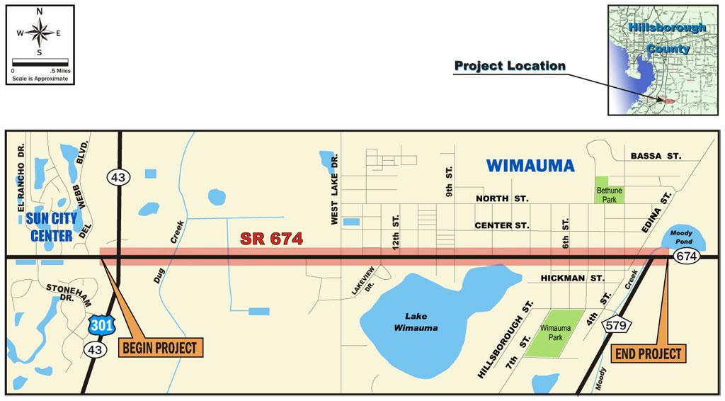
The Florida Department of Transportation (Department) conducted a Project Development and Environment (PD&E) Study to evaluate improvements along the segment of State Road (SR) 674 that extends from US Highway (US) 301 (SR 43) to County Road (CR) 579, in Hillsborough County, Florida. The length of this project was approximately 2.4 miles. The level of environmental documentation for this study was a State Environmental Impact Report (SEIR). The design year for the improvements was Year 2030.
The objective of this PD&E Study was to document the engineering and environmental analyses that were performed for this project so that the Department could reach a decision on the type, location, and conceptual design of the necessary improvements of SR 674 to accommodate future traffic demand in a safe and efficient manner. This study documented the need for the improvements as well as the procedures utilized to develop and evaluate various improvement alternatives.
SR 674 is an east-west route in southern Hillsborough County connecting the communities of Ruskin, Sun City Center, Wimauma, and Ft. Lonesome. Along its path, SR 674 intersects with six major north-south routes: US 41 (SR 45), I-75 (SR 93A), US 301 (SR 43), CR 579, CR 39 and SR 37. SR 674 is functionally classified by the Department as an urban minor arterial and is also designated as a hurricane evacuation route. The acceptable Level of Service (LOS) for this facility is LOS D or better.
Study Purpose and Need
The average annual daily traffic (AADT) volumes along SR 674 for 2004 in the study area, which range from 8,600 vehicles per day (vpd) in Wimauma (east of West Lake Drive) to 12,200 vpd east of US 301 (SR 43), exceed the capacity of the two-lane roadway resulting in peak hour LOS E. Due to planned development in the immediate vicinity of SR 674, these conditions should be expected to further deteriorate to LOS F in the future should no improvements be made to this facility. By the design year 2030, the AADT volumes in the study area should be expected to range from 17,800 vpd in Wimauma (106% growth) to 41,700 vpd just east of US 301 (SR 43) (241% growth).
Review of the Department’s crash records also revealed above normal crash occurrences on this facility. Study of the causes that could potentially contribute to the high crash rates along this segment of SR 674 eliminated factors such as poor weather conditions, poor lighting or sight distance conditions, driving under the influence, and substandard geometry, pointing to the increasing traffic congestion as the most probable cause.
The Final Corridor Management Report1, prepared by the Department on SR 674 in August 2006, evaluated the design year (2030) traffic conditions in the study area. To accommodate the projected transportation demand along the study segment of SR 674 at an acceptable LOS D or better during the design year, this report recommended that SR 674 be widened to a four-lane facility throughout the study area with the exception of the segment between US 301 (SR 43) and West Lake Drive that would require widening to six lanes.
Proposed Improvements
Recommended Alignment – Appendix A provides conceptual plans of the ultimate improvements for the “Recommended Alternative” for SR 674. Appendix B provides conceptual plans for the staged improvements for the initial widening of SR 674. The widening improvements of SR 674 generally follow the existing alignment.
From US 301 (SR 43) to West Lake Drive, SR 674 will remain centered on the existing alignment for the initial stage of the improvements. Future widening of this segment to six lanes will require widening to the north. From West Lake Drive to 7th Street, SR 674 will be widened to the south, and from 7th Street to the end of the project at CR 579, SR 674 will be widened to the north.
Recommended Typical Sections – A staged four-lane urban typical section is initially recommended for Segment 1 of SR 674 from US 301 (SR 43) to West Lake Drive. It provides a 12-foot-wide outside travel lane and an 11-foot-wide to 12-foot-wide inside travel lane in each direction, a 22-foot-wide median, 4-foot-wide bicycle lanes and 6-foot-wide concrete sidewalks on both sides, and requires a minimum of 100 feet of right of way.
In the future when the need for further widening of Segment 1 of SR 674 from US 301 (SR 43) to West Lake Drive is justified by an updated traffic analysis and is consistent with the Hillsborough County Long-Range Transportation Plan at the time, a six-lane urban typical section is recommended for Segment 1 of SR 674 from US 301 (SR 43) to West Lake Drive. It would provide three 12-foot-wide travel lanes in each direction, a 22-foot-wide median, 4-foot-wide bicycle lanes and 5-foot-wide concrete sidewalks on both sides, and would require 126 feet of right of way.
A four-lane urban typical section is recommended for Segments 2, 3 and 4 of SR 674 from West Lake Drive to CR 579. It provides two 12-foot-wide travel lanes in each direction, a 22-foot-wide median, 4-foot-wide bicycle lanes and 5-foot-wide concrete sidewalks on both sides and would require 102 feet of right of way.