click image to view map
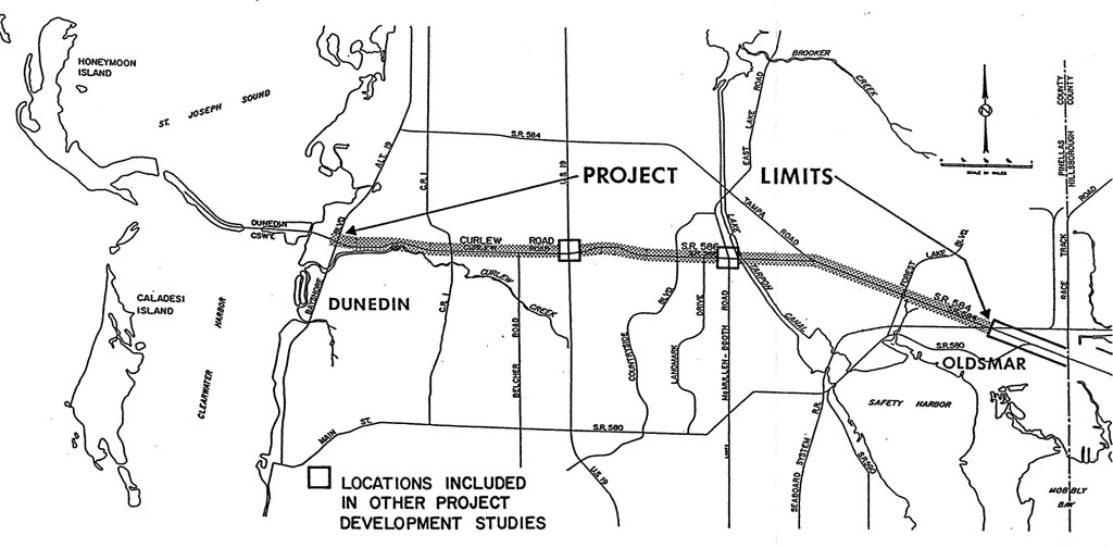
State Road (SR) 586 and SR 584 are urban major arterials locally known as Curlew Road and Tampa Road. The SR 586/SR 584 project is in the northern portion of Pinellas County and extends from Alternate U.S. 19 (Bayshore Blvd) in Dunedin to the Seaboard Coastline Railroad in Oldsmar. Total length of the project is approximately seven miles — with 5 1/3 miles along SR 586 and 1 2/3 miles along SR 584. Together, SR 586 and SR 584 provide the most direct transportation route between northern Pinellas County and the Greater Tampa Area. Extended westerly beyond Alternate U.S. 19 as Dunedin Causeway Blvd, this roadway provides the only land connection to Honeymoon Island State Park, a relatively new state recreational facility.
The existing roadway has segments of two-lane and three-lane pavement throughout its length. Most of the three-lane improvements were completed in early 1987 and were complemented with the reconstruction of several intersections. These recent improvements have provided an additional measure of safety and capacity, but do not fully meet the current needs or long-term needs of the SR 586/SR 584 corridor.
Pinellas County, through its Year 2010 Long Range Transportation Plan, calls for the improvement of SR 586 as a six-lane urban major arterial from west of Alternate U.S. 19 to SR 584. This plan also calls for six lanes on SR 584 from SR 586 to the Seaboard Coastline Railroad. Beyond the railroad, SR 584 would connect to SR 580.
Generally, traffic on SR 586 will double between 1986 and 2010. While future volumes on SR 584 will be dependent on roadway network expansion into northeast Pinellas County and northwest Hillsborough County, traffic on SR 584 is expected to increase a minimum of from 67 percent to 86 percent for the 24-year period. Without additional traffic lanes, operational conditions on SR 586 and SR 584 will become intolerable.
Corridor alternatives were explored to the north and south of both SR 586 and SR 584. No existing corridors having sufficient right-of-way width or adequate continuity within reasonable distance of SR 586 are available. Significant impacts to the cohesion and character of established neighborhoods would result with project development in any alternate corridor. Although there is a potential need for a transportation corridor beginning in the vicinity of the SR 584/SR 586 merge and extending to Linebaugh Avenue in Hillsborough County, this corridor is not a viable location for serving the transportation needs in the existing SR 586/SR 584 corridor west of SR 580. This Linebaugh extension corridor would form a major east-west transportation link between the planned development in northwest Hillsborough County and northeast Pinellas County.
Alternate designs within the preferred corridor were developed to include desirable, minimum and compromise options. These options include shared lanes for bicycles; 11-foot vs. 12-foot traffic lanes; 14-foot flush median vs. 22-foot and 30-foot raised medians; and, 10-foot vs. 12-foot border widths. Typical right-of-way requirements for these three alternative cross sections would be 100 feet, 118 feet, 122 feet, and 130 feet. Any one of the typical cross sections, if implemented, will cause damages to fronting properties. A maximum number of five buildings would be damaged or severed. Other damages relate to property acquisition.
Recommendations favor the cross section with a 22-foot raised median. Twelve-foot borders will be used along the project for an added measure of pedestrian safety. Typical right-of-way width will be 122 feet. Six lanes are recommended for the entire project length. These will consist of four 12-foot traffic lanes and two 14-foot outside traffic lanes for shared motor vehicle and bicycle use.
Study Purpose and Need
East-west travel along SR 586 and SR 584 is expected to increase as a consequence of population and employment growth. The attractiveness of this corridor can only be amplified because of its location and the continued growth in northern Pinellas County and northwest Hillsborough County. Locally named Curlew Road and Tampa Road also lead into Dunedin Causeway Boulevard, which is the only land connection to Honeymoon Island State Park. Future improvements for these corridor roadways have been listed in the Pinellas County Year 2010 Long Range Transportation Plan. Dunedin Causeway Boulevard will have two-lane, four-lane, and six-lane improvements. Curlew Road is planned for six lanes from Alternate U.S. 19 to Tampa Road. Six lanes are planned for Tampa Road from Curlew Road to the Seaboard Coastline Railroad. East of the railroad, Tampa Road will carry six lanes and eight lanes as part of the SR 580 improvement project. The plan fully recognizes this corridor as an important cross-county transportation link. This report documents existing characteristics and conditions on SR 586 and SR 584 along with the need for an improved facility. Improvement alternatives are identified, described, and evaluated.
Proposed Improvements
Alternate B is the recommended design alternate for the Curlew Road/Tampa Road project. It is a six-lane urban section with 22-foot raised median, four 12-foot traffic lanes, and two 14-foot outside lanes for shared use by motor vehicles and bicycles. Alternate B, as shown in Exhibit 9, will have a slight modification. Recommendations include 12-foot borders as opposed to the 10-foot borders shown in Exhibit 9. The 12-foot borders also allow for three feet between the back of curb and edge of sidewalk compared to having the sidewalk edge at the back of curb. Roadside elements within the 12-foot border will be identical to those shown for Alternate C in Exhibit 9. This will provide an additional measure of pedestrian safety. Each border will consist of a two-foot Type ‘F’ curb and gutter, three-foot grass strip and five-foot sidewalk. Two feet are allowed outside the sidewalk for utility pole lines and/or matching existing conditions. Typically, 122 feet of right-of-way will be needed except along SR 584 between the ‘Y’ and Forest lakes Boulevard, where right-of-way width will be 118 feet. This segment of SR 584 has a 25-foot utility easement on the south side of the roadway which can partly be utilized for project development. Distance between the back of curb and edge of sidewalk will be identical to other locations along the project.