click image to view map
The existing land use adjacent to the S. R. 57 4 corridor transitions through two areas of generalized land use characteristics. In general, from the western terminus eastward the land uses transition from dense development (medium scale shopping centers, office/professional office, medical facilities, service stations, restaurants and community facilities) to low density development (mixture of agricultural, commercial, and planned and residential developments). Although vacant land exists within the Study corridor, future developments are planned for most of this area.
S.R. 574 is currently a six-lane urban section west of C.R. 579, which transitions to a three-lane rural section (with a two-way left-turn lane) east of Highview Road. The three-lane section is retained until Kingsway Road, where the roadway transitions to a two-lane section that proceeds to Mcintosh Road. The existing posted speed limits along S.R. 574 are 45 mph and 50 mph.
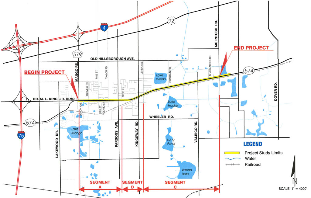
The S.R. 574 project corridor is divided into three segments for analysis purposes. Segment “A” is approximately 1.1 rniles in length, and it consists of the portion of S.R. 574 from C.R. 579 (Mango Road) to east of Parsons Avenue. Segment “B” proceeds eastward along S.R. 574 from east of Parsons Avenue to east of Kingsway Road, and it is approximately 0.6 miles in length. The portion of S.R. 574 from east of Kingsway Road to east of Mcintosh Road comprise Segment “C”, which is approximately 1.9 miles in length.
Study Purpose and Need
The current FOOT standards on the quality of traffic operations along facilities such as S.R. 574 require that a Level of Service (LOS) D or better should be provided within the urbanized area of the Study corridor. A LOS C or better is usually required for non-urbanized areas. However, the section of this corridor, from Kingsway Road eastward to the end of the Study’s limits, should be considered for LOS D due to the expected transition in the future to an urban environment. As part of the Final Traffic Technical Memorandum’•, a LOS analysis was conducted for the Study corridor to determine the existing and future year 2025 operating conditions at each intersection and segment.
The LOS was established for segments along S.R. 574, from C.R. 579 to Mcintosh Road, based on the existing and design year 2025 average daily traffic volumes (ADTs). The existing LOS varies from A to F for different segments within the Study corridor. It is anticipated that without improvements along S.R. 574, all of the segments from C.R. 579 to Mcintosh Road will be deficient by the design year (2025). Refer to Section 6.6 of this report for a discussion of the projected LOS for 2025.
Based on the results of this analysis, only three of the seven intersections are operating at a LOS Cat the present time. Currently, the intersection of S.R. 574 and C.R. 579 is operating at a LOS D, and the intersections of S.R. 574 at Parsons Avenue and at Mcintosh Road are currently operating at LOS E. The intersection of S.R. 574 and Highview Road is currently operating at a LOS F. It is anticipated that all seven of the intersections will be operating at a LOS F by the design year (2025) if improvements are not constructed along S.R. 574. However, if a “Build” alternative is constructed, all of the intersections with the exception of S.R. 574 and C.R. 579 would experience an improved LOS.
Proposed Improvements
The recommended alignment generally follows the existing centerline of the roadway with several shifts to reduce impacts to established commercial properties and to avoid a cemetery in the western portion of the project. The recommended alignment for the eastern portion of the project was controlled by a twenty-five foot offset from the proposed right-of-way line to the centerline of the existing, active CSX railroad tracks, which is the minimum dimension that has been acceptable to CSX in previous District Seven projects.
There is a box culvert at Lake Weeks Creek and a bridge (FDOT Bridge No. 1 00033) over Baker Canal within the eastern portion of the project, which would require modifications to accommodate the multi-laning of S.R. 574 by constructing a longer culvert at Lake Weeks Creek and a new bridge or bridge culvert at Baker Canal.
It is anticipated that minor modifications will be required along the side streets to accommodate the additional lanes on S.R. 574. Right-of-way acquisition is anticipated for various locations within the project corridor, and for storm water management ponds.
The limits of this Study were evaluated as three segments due to differing traffic and land use characteristics, and a separate recommended typical section was developed for each segment (each recommended typical section has a corresponding design speed and recommended posted speed). The segments and typical sections are as follows:
- Segment “A” proceeds from east of C.R. 579 to east of Parsons Avenue. The recommended typical section for this segment is a 5-lane urban typical section with a 40 mph design speed that contains a two-way left turn lane. This typical section provides a 5′ sidewalk and a 4′ designated bike lane in each direction, requires 94 feet of right-of-way, and will reduce the existing posted speed limit from 45 mph to 40 mph (per District policy for 5-lane urban typical sections). The alignment for this segment must avoid the St. Mary’s AME cemetery west of Taylor Road, and minimize the acquisition within the bank properties (including constructing gravity or retaining walls, as necessary) on the north and south sides of S.R. 574 and west of Parsons Avenue.
- Segment “B” proceeds from east of Parsons Avenue to east of Kingsway Road. The recommended typical section for this segment is a 4-lane suburban typical section with a 45 mph design speed, which contains a raised median on the inside and flush paved shoulders on the outside. This typical section provides a 5′ sidewalk beyond the roadside swale in each direction, the paved shoulders will also serve as bicycle facilities, it will require 123.5 feet of right-of-way, and will maintain the existing posted speed limit of 45 mph. The sidewalk on the south side of the roadway is not continuous due to the existence of the CSX railroad tracks near the Kingsway Road intersection.
- Segment “C” proceeds from east of Kingsway Road to east of Mcintosh Road. The recommended typical section for this segment is a 4-lane suburban typical section, similar to Segment “B” except that it is designed for a 60 mph design speed. This typical section provides a 5′ sidewalk beyond the roadside swale on the north side of the roadway, has paved shoulders in each direction, requires 131.5 feet of right-of-way, and will enable a 55 mph posted speed limit. A predominant feature of this segment is the railroad along the south side of the roadway, and the recommended alignment is based on the acquisition of a 25′ wide right-of-way parcel from CSX along the length of the segment (an additional 12′ width will be needed for exclusive right turn lanes at eastbound intersection approaches).
Additional recommendations are as follows:
- Prepare a lighting justification study for Segment “A” during the segment’s future design phase attenuation credits for the ponds. A drainage analysis should be performed to determine the seasonal high water and flooding characteristics of the basin on the west end of the project, and appropriate attenuation requirements (the PD&E is based on near worst case conditions).
- Early utility coordination, particularly for facilities within the CSX right-of-way that need to be acquired, should be performed. It should be noted that extensive utilities exist along the CSX railroad and that the cost to relocate these facilities should be included in the Department’s construction funding.
- Side street alignment shifts and reduced curb radii should be considered during design to prevent the need of corner clips in those areas where other right-of-way does not need to be acquired.