click image to view map
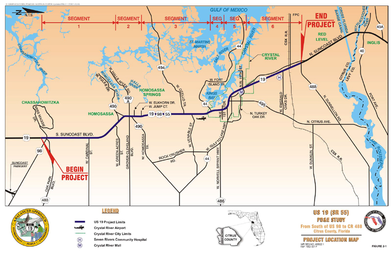
The FDOT conducted a PD&E Study for improvement alternatives along US 19 (SR 55) from south of US 98 (milepost 1.730) to North Dunnellon Road (CR 488) (milepost 20.742) in Citrus County, Florida.
The PD&E Study limits encompass the portion of US 19 from south of US 98 to North Dunnellon Road (CR 488) in western Citrus County (Sections 1, 12, 13, 24, and 25 of Township 20 South, Range 17 East; Sections 3, 10, 15, 22, 26, 27, 34, and 35 of Township 19 South, Range 17 East; Sections 5, 6, 8, 17, 20, 21, 22, 27, 28, and 34 of Township 18 South, Range 17 East; Sections 30 and 31 of Township 17 South, Range 17 East; and Section 25 of Township 17 South, Range 16 East). The total length of the Study is approximately 18.8 miles (mi). US 19 is primarily a north/south rural principal arterial which follows the West Coast of Florida. Within the project limits, US 19 is part of the National Highway System (NHS) and the Florida Intrastate Highway System (FIHS). The facility serves as a major evacuation route for residents in Citrus County.
Study Purpose and Need
The purpose of the PD&E Study was to provide documented environmental and engineering analyses to assist the FDOT and the Federal Highway Administration (FHWA) in reaching a decision on the type, location and conceptual design of the necessary improvements, in order to accommodate future traffic demand in a safe and efficient manner. The PD&E Study also satisfied the requirements of the National
Environmental Policy Act (NEPA) and other Federal requirements in order to qualify the project for federal-aid funding of future development phases of the project.
This Study documents the need for the improvements, and presents the procedures utilized to develop and evaluate various improvement alternatives. Information relating to the engineering and environmental characteristics essential for alternatives and analytical decisions were collected. Design criteria have been established and preliminary alternatives have been developed. The comparison of alternatives was based on a variety of parameters utilizing a matrix format. This process identified the alternative that would have minimal impacts, while providing the necessary improvements. The design year for the analysis is 2025.
Proposed Improvements
The Recommended Alternative for this Project Development and Environment (PD&E) Study is described as follows:
The Recommended Alternative for Segment 1 includes widening of the existing four-lane roadway to a six-lane divided rural roadway with a 42-foot (ft) depressed grass median. Southbound US 19 is widened to the outside to accommodate an additional 12-ft travel lane and an 8-ft shoulder, of which 5 feet (ft) is paved. The existing southbound inside travel lane will require asphalt overbuild to remove the crown in the existing pavement. An 8-ft paved shoulder is also added within the median.
The Recommended Alternative for Segment 2 includes two proposed typical sections. The proposed typical section from West Green Acres Street to West Yulee Drive (CR 490) and from West Elkhorn Drive to West Jump Court consists of a six-lane divided urban typical section with a 30-ft raised median. This typical section contains three 12-ft travel lanes and a 4-ft bike lane in each direction separated by a 30-ft raised median. A 12-ft multi-use path and 5-ft sidewalk are provided along the existing western and eastern ROW lines, respectively, from West Green Acres Street to West Yulee Drive (CR 490). From West Elkhorn Drive to West Jump Court, a 5-ft sidewalk is provided along both sides of the roadway adjacent to the ROW line. This typical section utilizes a centered alignment and is accommodated within the existing ROW. Additional ROW will be required for stormwater management facilities. The proposed design speed for this typical section is 50 mph.
The Recommended Alternative for Segment 3 consists of a six-lane divided urban typical section with three 12-ft travel lanes and a 4-ft bike lane in each direction separated by a 30-ft raised median. Sidewalks, 5 ft in width, are provided along both sides of the roadway, separated from the curb by a grass buffer strip. The proposed design speed for this typical section is 50 mph.
The Recommended Alternative for Segment 4 consists of reconstructing the existing median from a two-way left-turn lane to a 17-ft raised median. In areas where left turn lanes are proposed, the raised median will be reduced to a 4-ft traffic separator with a single 12-ft exclusive left-turn lane. This alternative also includes milling and resurfacing of the existing roadway to allow for three 12-ft travel lanes in each direction. Multi-use paths, 12 ft in width, are proposed along both sides of the roadway, adjacent to the ROW line to accommodate pedestrians and bicyclists. The proposed design speed for this alternative is 40 mph.
The Recommended Alternative for Segment 5 consists of a six-lane divided urban typical section with three 12-ft travel lanes in each direction separated by a 16-ft raised median. This typical section contains two 11-ft travel lanes and one 12-ft outside travel lane in each direction. Sidewalks, 6 ft in width, are provided along both sides of the roadway adjacent to the back of curb. A pedestrian overpass is proposed over US 19 at the Crystal River bike path. Due to the heavily commercialized land use in this segment and the addition of a narrow raised median, a design speed of 40 mph is proposed for this alternative.
The Recommended Alternative for Segment 6 consists of Transportation System Management (TSM) improvements. The improvements include the following:
- Extending the northbound and southbound turn-lanes at North Dunnellon Road (CR 488),
- Adding an exclusive right-turn lane along westbound North Dunnellon Road (CR 488),
- Signalizing the intersection of US 19 and North Dunnellon Road (CR 488) if warranted,
- Replacing the flashing signal with a full signal at Seven Rivers Community Hospital entrance if warranted,
- Upgrading existing traffic signals to mast arms at Seven Rivers Community Hospital and West Powerline Street. Pedestrian signals and cross walks will also be included at each signalized intersection.