click image to view map
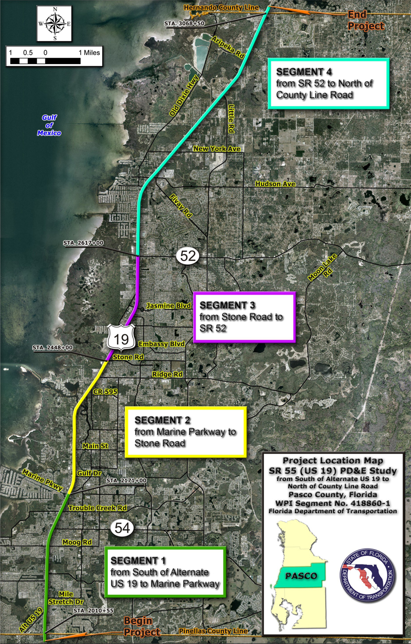
The Florida Department of Transportation (FDOT) conducted a Project Development and Environment (PD&E) Study to evaluate capacity alternative improvements along SR 55 (US 19). The project limits are from south of Alternate US 19 in Pasco County (south project limits) to north of County Line Road in Hernando County (north project limits). The study limits length is 19.85 miles. The project location map illustrates the location and limits of the PD&E study.
SR 55 (US 19) is a federal highway that initially served regional travel throughout the west coast of Florida. Due to the tremendous residential and commercial growth along the corridor over the past twenty years, the role of SR 55 (US 19) in Pasco County has expanded. SR 55 (US 19) has evolved into a commuter corridor and a roadway for local traffic destined to commercial establishments along the corridor. The high speed, high volume commuter traffic competes with tourist and local traffic entering and exiting the roadway, creating mobility and safety concerns.
Study Purpose and Need
The objective of the PD&E study was to provide documented environmental and engineering analyses, which would help the Department and the Federal Highway Administration (FHWA) reach a decision on the type, conceptual design and location of the necessary improvements within the SR 55 (US 19) PD&E Study limits to accommodate future transportation needs in a safe and efficient manner.
Proposed Improvements
Both the existing and design year conditions were evaluated, and various improvement alternatives were considered, including a No-Build Alternative, in order to determine the most appropriate recommendation for this project. After a thorough technical analysis and a comprehensive public involvement process, the study concluded that, without capacity improvements made to the existing roadway facility, future increases in traffic volume will further exacerbate current deficient levels of service (LOS) on SR 55 (US 19). The following proposed improvement concepts are, therefore, recommended to improve existing and future traffic conditions.
- The Recommended Alternative consists of grade separating the SR 55 (US 19) mainline over the intersections of SR 54, Ridge Road, SR 52 and County Line Road. A modified Tight Urban Diamond Interchange (TUDI) with provisions for u-turn movements is the recommended concept for accomplishing the proposed grade separation. This alternative is recommended because it minimizes the need to acquire costly ROW within the SR 55 (US 19) study limits. The Recommended Alternative utilizes pier supported concrete slabs to cantilever the SR 55 (US 19) mainline over the at-grade travel lanes at the four intersection locations. The use of the cantilevered structure reduces ROW impacts.
- The recommended roadway typical section is grade-separated and provides for a six-lane SR 55 (US 19) mainline section constructed on pile supported concrete slabs. A cantilevered overhang is provided on both sides of the mainline section to allow at-grade travel lanes to be placed beneath the elevated structure. The use of a cantilevered overhang and 11-foot (ft) at-grade travel lanes minimize the overall footprint to 200 ft. An illustration is provided of the recommended typical section used for grade separating the SR 55 (US 19) mainline at the intersections of SR 54, Ridge Road, SR 52 and County Line Road. The 200-ft footprint coincides with the existing minimum ROW width of 200 ft along the SR 55 (US 19) mainline at the intersections of SR 54, SR 52 and County Line Road. The length of the overhang varies by location in order to maintain the typical section within existing ROW. The overhang at SR 54, SR 52, and County Line Road varies between 5 ft and 17 ft. The width of the cantilever at the Ridge Road location would need to be 27 ft on the west side and 27 ft on the east side to fit within the existing 150 ft ROW envelope. In addition, 4-ft wide undesignated bicycle lanes and 6-ft wide sidewalks are provided on both sides of the at-grade portion of the typical section to safely accommodate pedestrians and bicyclist. The proposed design speed for this typical section is 50 miles per hour (mph).