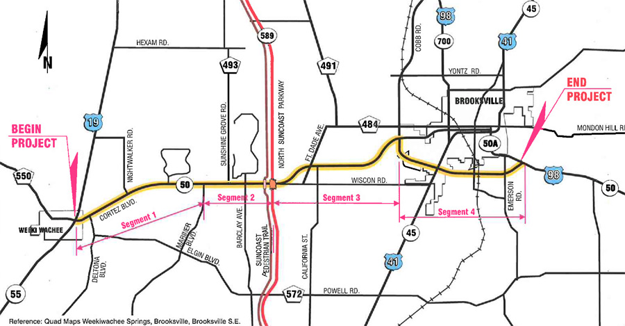
click image to view map
The Florida Department of Transportation (FDOT) conducted a Project Development and Environment (PD&E) Study Reevaluation, which evaluated capacity improvement options along S.R. 50 (Cortez Boulevard) in Hernando County, Florida. The proposed project involved widening S.R. 50 from the existing 4-lane typical section to a 6-lane typical section from U.S. 19 to the east intersection of S.R. 50/S.R. 50A [along the Brooksville Bypass], a distance of approximately 13.7 miles. The widening of the segment of S.R. 50 from U.S. 19 (S.R. 55) to the west intersection of S.R. 50/S.R. 50A was proposed to be widened to the outside; whereas the remainder of the project, from the west intersection of S.R. 50/S.R. 50A to the east intersection of S.R. 50/S.R. 50A [along the Brooksville Bypass], was proposed to be widened to the inside.
Study Purpose and Need
The purpose of this PD&E Study Reevaluation was to review the previous PD&E Study that was performed for the project and document any changes that have occurred since the Federal Highway Administration’s (FHWA) approval on 3/22/90. The previous PD&E Study being reevaluated was S.R. 50 from U.S. 19 (S.R. 55) to the eastern intersection of S.R. 50/S.R. 50A [along the Brooksville Bypass]. This PD&E Study Reevaluation included analyses to determine the type, conceptual design, and location of improvements for accommodating present and future traffic demands, social and economic demands, and conformance to present plans and policies in a safe and efficient manner. This Reevaluation also satisfied the requirements of the National Environmental Policy Act (NEPA) and all other applicable Federal requirements in order to receive federal funding for the design, right-of-way acquisition and construction of the project.
Improvements to this section of S.R. 50 are needed because the existing roadway will not be capable of providing an adequate Level of Service (LOS) based on the demands of the future traffic projections. Hernando County MPO’s 2025 LRTP includes the widening of S.R. 50 from U.S. 19 (S.R. 55) to the east intersection of S.R. 50/S.R. 50A [along the Brooksville Bypass], which is also included in an appendix of Hernando County’s Comprehensive Plan. In addition, portions of the project corridor are included in the FDOT’s 5-Year Tentative Work Program for capacity improvements.
Proposed Improvements
The alignment for the entire project corridor is primarily within the existing right-of-way. Specifically, alternative alignments were not necessary along S.R. 50, because the previous PD&E Study established the need for S.R. 50 from U.S. 19 (S.R. 55) to the eastern intersection of S.R. 50/S.R. 50A [along the Brooksville Bypass] to be initially widened to the existing 4-lane typical section and expandable to a 6-lane typical section. It should be noted that the recommendations of the previous PD&E Study were approved by FHWA on 3/22/90.
The alignment for the section of the project corridor from west of the west S.R. 50/S.R. 50A intersection to east of the west S.R. 50/S.R. 50A intersection [along the Brooksville Bypass] is limited by the existing urban typical section as well as the development and right-of-way constraints within this section of the project corridor. In addition, the portion of the project corridor from east of the west S.R. 50/S.R. 50A intersection to the east S.R. 50/S.R. 50A intersection [along the Brooksville Bypass] will be widened strictly to the inside per the previous PD&E Study.
There are five existing concrete box culverts (CBC) under S.R. 50 within the limits of the project. With the proposed roadway widening, it is anticipated that the final design would require some of the existing cross drains to be extended or replaced.
It is anticipated that minor modifications will be required along the side streets to accommodate the additional lanes along S.R. 50. Right-of-way acquisition will be required for right-turn lanes at unsignalized and signalized intersections as well as for storm water treatment facilities.
The S.R. 50 Reevaluation project corridor was divided into four segments for analysis purposes based on existing land use, projected traffic volumes, and roadway characteristics. The recommended typical sections are as follows:
- 6-Lane Rural Typical Section: From U.S. 19 (S.R. 55) to west of the western intersection of S.R. 50/S.R. 50A
The recommended typical section for this portion of S.R. 50 is a 6-lane rural section (65 mph design speed) with 12-foot lanes, 10-foot shoulders (5-foot paved), and 40-foot depressed median within 200 feet of existing right-of-way. It also includes a 12-foot shared use path and a 5-foot sidewalk on the south and north sides of the roadway, respectively.
- 6-Lane Urban Typical Section: From west of the western intersection of S.R. 50/S.R. 50A to east of the western intersection of S.R. 50/S.R. 50A [along the Brooksville Bypass] and west of Candlelight Boulevard to east of Ray Browning Road [along the Brooksville Bypass]
A 6-lane urban typical section (50 mph design speed) is recommended for these sections of S.R. 50 with 12-foot lanes, 4-foot outside bicycle lanes with curb and gutters, 5-foot sidewalks and a 22-foot raised median that requires a minimum of 126 feet of proposed right-of-way.
- 6-Lane Modified Urban Typical Section: From east of the western intersection of S.R. 50/S.R. 50A to west of Candlelight Boulevard [along the Brooksville Bypass] and east of Ray Browning Road to the eastern intersection of S.R. 50/S.R. 50A [along the Brooksville Bypass]
The recommended typical section for these sections of S.R. 50 is a 6-lane modified urban typical section (50 mph design speed) with 12-foot lanes, 10-foot outside shoulders (5-foot paved with no curb and gutters), 5-foot sidewalks and 22-foot raised median within the existing right-of-way.
Additional recommendations are as follows:
- Early utility coordination.
The following recommendations should be considered during the design phase:
- Reducing the proposed right-of-way in certain areas of the project, including the southeast quadrant of the Suncoast Parkway interchange and along the Rick Matthews Buick dealership near Sta. 815+00, should be evaluated. A possible approach is to apply storm sewers to reduce drainage ditch requirements, and then move the sidewalks closer to the roadway. The effect on clearzones and other clearance and safety requirements needs to be included in this evaluation.
- Coordination should be performed with the new Brooksville Hospital to determine if a shared pond can be planned on their site (Sta. 273+00, near the southeast quadrant of the S.R. 50 and Lykes Dublin Road intersection). It should be noted that the PD&E Study’s Pond Siting Report evaluated a separate pond for S.R. 50 along this portion of the corridor, which was referred to as Basin J in the report.