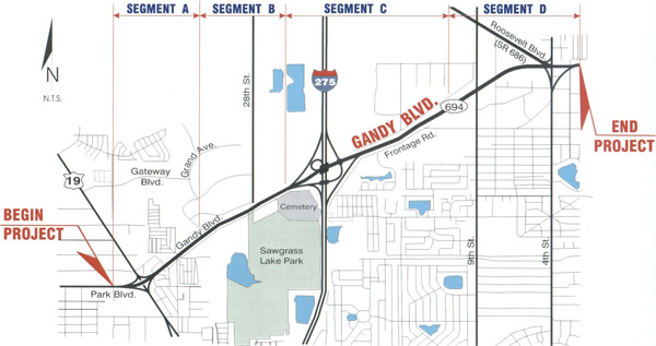
Click image to view map
The Florida Department of Transportation (FDOT) conducted a Project Development & Environment (PD&E) study to evaluate the proposed improvements to Gandy Boulevard (SR 694) from west of US 19 to east of 4th Street in St. Petersburg, Florida, a distance of approximately 3.9 miles.
The FDOT had initiated a previous PD&E Study on this section of Gandy Boulevard in 1991. An Alternatives Public Workshop was held on November 16, 1993, at the First Baptist Church of St. Petersburg. A recommended alternative was developed, and a Public Hearing was scheduled. However, before the Hearing could be held, the Study was suspended in 1994 due to the advent of a federally required Major Investment Study (MIS). The FDOT initiated the Gandy Corridor MIS in July 1996. The limits of the Study, which was completed in May 2000, were from just west of US 19 in Pinellas County to the intersection of Dale Mabry Highway in Hillsborough County. Both the initial PD&E Study and the MIS process relied heavily on community input to develop alternatives. This current PD&E Study has analyzed the recommended alternative from both the initial PD&E Study and the MIS. The resulting “Recommended Build” Alternative is a synthesis of the two.
A Public Hearing was held on March 14, 2002, from 4:30 p.m. to 7:30 p.m. at the First Baptist Church of St. Petersburg, Heritage Hall, 1900 Gandy Boulevard, St. Petersburg, Florida. Elected officials, and various agency representatives were notified of the meeting by first class mail at least 25 to 30 days prior.
Study Purpose and Need
The need for improvement along the Gandy Boulevard (SR 694) Corridor was established
based on the evaluation of the following:
- Current quality of traffic operations in the study area;
- The expected future quality of traffic operations along Gandy Boulevard (SR 694) under the No-Build Alternative;
- Traffic safety statistics for the period between 1994 and 1998; and
- The projected future socio-economic growth in the region of the project.
Proposed Improvements
Within the project limits, Gandy Boulevard is functionally classified as an east-west urban arterial highway. It also serves as a major evacuation route for residents in Pinellas County. From US 19 to west of I-275, the existing typical section is a six-lane divided roadway with open drainage ditches on both sides and two-way, two- lane frontage roads on the north and south side of Gandy Boulevard. The depressed median varies between 24 feet (ft) and 60 ft. The existing right-of-way (ROW) varies between 160 ft and 380 ft. From west of I-275 to east of 4th Street, the existing typical section is a four-lane divided roadway that also has two-lane, two-way frontage roads on the north and south side of Gandy Boulevard with open drainage ditches on both sides of the roadway. The depressed median contains swales and varies in width between 36 ft and 275 ft. The existing ROW varies between 220 ft and 550 ft.