click image to view map
Pinellas County, in coordination with the Florida Department of Transportation (FDOT) District Seven, and the Federal Highway Administration (FHWA) is conducting a Project Development and Environment (PD&E) Study to evaluate alternatives to remove, rehabilitate or replace the existing Beckett Bridge (Bridge no. 154000) in Tarpon Springs, Pinellas County, Florida. The existing bridge was originally constructed in 1924 as a timber structure with a steel movable span. The fixed timber approach spans were replaced with concrete approach spans in 1956. The bridge has been determined to be eligible for listing in the National Register of Historic Places (NRHP). Eligibility is based on the bridge’s contribution to early development of the area and because it is one of a few known, pre-1965, highway single-leaf rolling-lift bascule bridges remaining in Florida. Since 1956, major repairs were performed in 1979, 1998, and in 2011. Major rehabilitation or replacement of the bridge is needed to keep the bridge open and operating efficiently.
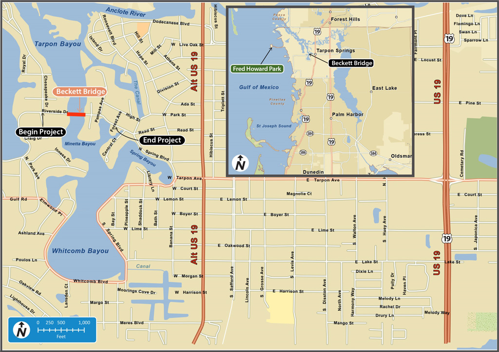
The project limits extend along Riverside Drive from Chesapeake Drive across Whitcomb Bayou to Forest Avenue, a distance of approximately 0.3 mile. The existing two-lane bridge connects areas west and north of the Bayou to downtown Tarpon Springs. The bridge is also located on a popular route for access to Fred Howard Park, a Pinellas County park located approximately 3.1 miles west on the Gulf of Mexico. Riverside Drive/North Spring Boulevard is an extension of Tarpon Avenue, which is a designated evacuation route. Beckett Bridge provides access to major north/south arterials including Alternate US 19 and US 19 for coastal residents during hurricane evacuation. The bridge also provides access for emergency vehicles, including police, ambulance and fire. Alternate routes (that do not require crossing of the Beckett Bridge) are available for travel to and from the areas mentioned above, and for emergency response.
Study Purpose and Need
According to recent (07/31/2012) FDOT inspection reports, the existing bridge has an overall Structure Inventory and Appraisal Sufficiency Rating of 44.9 out of 100. (Sufficiency ratings are a method of evaluating highway bridges by calculating a numeric value between 0 and 100, indicative of bridge sufficiency to remain in service). The bridge is considered functionally obsolete. This designation is based primarily on the substandard clear roadway width of only 20 feet and substandard roadway safety features. The existing typical section consists of one, 10-foot wide travel lane in each direction and 2-foot 2-inch-wide sidewalks separated by a curb on both sides of the bridge.
Minimum required lane and shoulder widths prescribed by the American Association of State Highway and Transportation Officials (AASHTO) are not met. The sidewalks on the bridge are narrow and do not meet current accessibility requirements established by the Americans with Disabilities Act (ADA). The bridge railings do not meet current standards for pedestrian safety or geometric and crash testing safety standards for vehicles. Approach guardrail and transitions and end treatments also do not meet current safety standards.
There are no official USCG navigational clearance guidelines for this waterway at this location. The existing vertical clearance at the fenders is six feet. The tip of the bascule leaf overhangs the fender with the leaf fully raised, limiting the clearance for a portion of the channel between the fenders. It is likely that unlimited vertical clearance was provided for the entire width of the channel when the bridge was originally constructed. The existing horizontal clearance between the fenders is 25 feet.
Although the bridge is not considered Structurally Deficient, the bridge has a substandard load carrying capacity requiring weight restrictions. The bridge is currently posted for legal loads limited to 12-ton Single Unit Trucks and 15-ton Combination Trucks. Repairs in 1979 and 1988 included installation of crutch bents due to settlement and lateral stability concerns. Repairs in 2011 were performed to correct issues with the operating machinery and bascule leaf alignment.
Proposed Improvements
The Recommended Alternative is replacement of the existing two-lane bascule Beckett Bridge with a new two-lane movable bridge. In accordance with the Section 106 Memorandum of Agreement, the design of the new bridge will be a single-leaf, rolling lift bridge type of similar design and scale of the historic Beckett Bridge. The proposed bridge would provide 7.8 feet of vertical clearance over the navigation channel at the fenders in the closed position. Unlimited vertical clearance will be provided in the open position for the width of the channel between the fenders. The horizontal clearance between the fenders will be 25 feet. The new bridge would be constructed within existing right-of-way, on approximately the same alignment as the existing bridge. The proposed bridge will be approximately 19 feet wider than the existing bridge.
No additional right-of-way will be required. No business or residential relocations will result from construction of the proposed improvements. The proposed bridge is likely to qualify for a General Permit from SWFWMD and treatment of stormwater runoff from the bridge would not be required. However, if treatment of stormwater is required, it is anticipated that compensatory, offsite treatment will be acceptable. Accordingly, acquisition of additional right-of-way is not anticipated to address water quality concerns.
The proposed bridge typical section for the replacement low-level movable bridge has a total out-to-out width of 47.2 feet. The typical section includes two, 11-foot wide travel lanes with 5.5-foot shoulders that can function as undesignated bicycle lanes. Sidewalks, 6 feet wide, are proposed on both sides of the bridge.
The maximum proposed grade is five percent, which meets ADA requirements. Roadway reconstruction is limited to the bridge approaches. The approach roadway will return to existing grade at Pampas Avenue on the east side of the bridge. On the west side of the bridge, the approach roadway will return to existing grade just east of Chesapeake Drive. The approach roadway will be close enough to the existing grades at the driveways to the Bayshore Mobile Home Park, the Tarpon Springs Yacht Club and Venetian Court to allow connection of access to residential property driveways along Riverside Drive will still be accessible.
Resurfacing (only) is proposed between Forest and Pampas Avenues. The proposed roadway profile would be approximately two feet higher than the existing roadway at the west end of the bridge, and approximately four feet higher at east end of the bridge. Approximately 0.03 acre of wetlands will be impacted by the proposed replacement bridge. No perceptible noise impacts are anticipated.